24 November 2006

Vicksburg, Mississippi… I Like This Place!

400 miles into my walk

It's been awhile since I've updated my trip. This morning I woke up and realized that I'd already walked nearly 80 miles through the state of Mississippi and not once have I said a thing about it. Well it's not because there's nothing to note… far from it. Mississippi has put spring in my step, though it is Autumn. The fresh fragrance of pines on the cool, crisp air is such a relief from the humid, warmer days I spent in Louisiana.

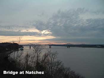
I crossed the river at Vidalia and walked into the city of Natchez, Mississippi right at sunset. The weather was already turning cooler and the sky was talking Autumn with high, light wispy clouds.

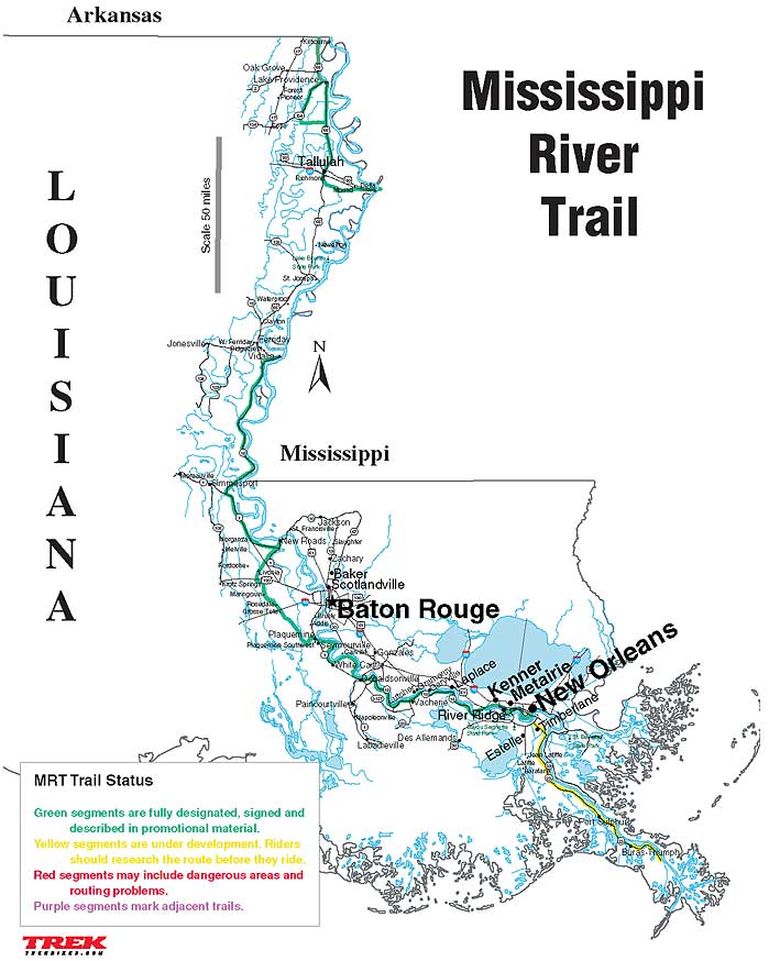
I headed toward the southern terminus of the Natchez Parkway off of Liberty Road. Technically, this is the starting point of the historical "beginning" of the Old Trace at milepost zero. The 444-mile Natchez Trace Parkway commemorates an ancient trail that connected southern portions of the Mississippi River, through Alabama, to salt licks in today's central Tennessee.

I walked along the Parkway for about 42 miles and saw some truly beautiful places: The Emerald Mound (one of the largest ceremonial mounds in the United States built and occupied between 1250 and 1600 AD by the ancestors of the Natchez people) and Mount Locust (standing on a land grant of 600 acres, dates from the English occupation of the Natchez District during the years 1763-1779 when it was part of British West Florida).

I veered off of the Natchez Parkway onto State Road 61 just south of Port Gibson to head due north towards Vicksburg. I knew that I would be back to walk the entire length of the Parkway, once I made it to Minnesota.

Now, Vicksburg is a really hip little city. It's has a pleasant mix of the old with the new. The Vicksburg National Military Park is probably the city's biggest draw. This park commemorates the campaign, siege and defense of Vicksburg during the Civil War. It is one of the most heavily monumented parks in the world with 1330 monuments, markers, tablets and plaques. The beauty and artistry of its monuments prompted one Civil War veteran to call this park, "the art park of the world.

As I walked along the many monuments within the park, I realized that most of the history I've been walking with along my Mississippi River trek had to do with war, natural disasters, and human suffering. It was time to look for lighter anecdotes. With winter coming on I needed side-trips that lifted my spirits and didn't remind me of the troubles, both past and present, of this world. That led me to Catfish Row Art Park.

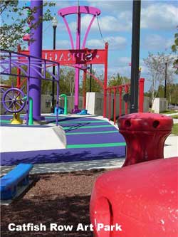
The Art Park at Catfish Row is a creative adventure into the history of the Mississippi River and the fabulous paddle wheel steamboats that once traveled it's mighty waters. It is a colorful park where sculptures are not monuments of past battles. It is a park nurtured by the community of Vicksburg. Art walls throughout the park are currently blank but will soon be transformed into beautiful historical works of art created by the people of Vicksburg. It is just the place I needed to see before continuing my journey north.

The air is now crisp and chilly. Winds are kicking up, blowing the last of the leaves my way. Winter will soon be here. And, as I hit the road, walking my way toward State Road 1, I reflect not on the wealth of history I've learned or the Thanksgiving meal I missed today, but on the many things I am thankful for each day. Happy Thanksgiving everyone.

Brian

07 November 2006

Trip to Bangkok

We brought our office staff on a trip to Bangkok, Thailand for 4 days. On Saturday morning I woke up and walked to the park near our hotel and fast walked 4 loops. The staff took a bus to visit a few of the sites around the city and I met up with them by walking throughout the city. Saturday I put in 40,000 steps and walked about 16 miles. Sunday we visited the floating market and the weekend market. Total miles for Sunday was only about 6 miles and 12000 steps... but a lot of shopping!! Monday I woke up and went back for a fast walk around the park to try and work off the great Thai food I ate (4.5 miles and 17,000 steps for the day. Thailand, in my opinion, has the best food in the world.


Oooops.... she's not a girl!!!


Family photo


My daughter's crab creation


Floating Market


Floating Market


Porcelain Temple

23 October 2006

River of History

296 miles into my River walk, I am beginning to understand and appreciate the valuable contributions and historical importance of the Mississippi River. This River has helped to shape the United States both physically and culturally.

After leaving New Roads, I came across the Old River Lock. Old River is the most amazing site along the entire Mississippi. In a word, the Corps of Engineers are successfully (for now) holding back the Mississippi and preventing it from changing course down the Atchafalaya. Should this change happen, the result would be the destruction of the Atchafalaya ecosystem and the inevitable loss of New Orleans and all the industry along the lower Mississippi. The Mississippi's existing channel would turn into a salt water estuary.

Look at a map of the state of Louisiana and you can see it is shaped something like a boot. Over the course of many millennia the bottom half of that boot has been created by the Mississippi. Southern Louisiana is built entirely of river sediment carried by water from as far away as the Rocky Mountains. As the Jefferson River gushes down a Montana mountainside it picks up little bits of that mountain and carts them off to the Missouri River. As the Wabash flows through prime Indiana farm land it picks up some of that land and carries it to the Ohio River. The process is cumulative until finally, the Mississippi, loaded with two million tons per day of washed away mountain and farm field, reaches sea level and slows down enough to unburden its load in southern Louisiana.

To build up all of southern Louisiana, the Mississippi has had to move around. Every couple of millennia it takes a major turn, abandons it's old channel, and finds a new one. The last time this happened was at the site where Donaldsonville now sits. Bayou Lafourche used to be the Mississippi. The next time this will happen will be at Old River.

And the next time that will happen I’ll hopefully be further north along the Mississippi and away from Old River.

Since leaving the Old River Lock, I’ve been heading north to Vidalia, by walking along Highway #15 which climbs on top of the levee, on the side, at the foot of, or near the levee, passing through miles and miles of plantation country.

As I walk through this rich agricultural countryside dotted with an occasional building complex, I try to imagine that at one time these fields provided cotton that was loaded onto ships, that floated down the Mississippi to New Orleans where it was transferred to ocean-going vessels that sailed into eastern ports or across the Atlantic. This region, like many others in the South, traded agricultural crops for manufactured goods. During the early 19th century it was of enormous interest to this region not to have tariffs on imported manufactured goods from Europe. With the Tariff Act of 1828 (known as the “tariff of abominations), discontent broke out in the South and the seeds of the Civil War were planted.

I’ll be in the small town of Vidalia soon. This is where I’ll cross the River for the third time, leaving Louisiana behind and entering into Mississippi.

09 October 2006

New Roads and False River

After walking about 242 miles from Venice, Louisiana, I’m now northwest of Baton Rouge and heading towards the Mississippi / Louisiana state border. Just ahead of me is a small town called New Roads. For a town with such a simpe name, New Roads has a very interesting history.

In 1699 the French explorer Iberville discovered a point on the Mississippi River where the river doubled back on itself. Time and high waters eventually allowed the river to change its course, taking the short cut and avoiding the 22-mile curve. The resulting oxbow lake was called "Fausse Riviere" in French, now, False River.

In 1822 a free woman of color named Catherine Depau, nicknamed "la fille Gougis," developed the original six-block area of town, now bounded False River, New Roads, St. Mary and Second Streets. Street signs in this area bear original names in French, as well as their current names. Eventually taking the name of New Roads, the town became the seat of parish government in 1847, and began to thrive.

This area was one of the earliest settlements in the entire Louisiana Purchase, where it attracted planters to farm its rich fertile delta soil. Some of the nation’s largest sugar plantations are still thriving on land surrounding the City of New Roads.

Settlers built homes ranging from stately plantation “great houses” to modest cottages. Fortunately the majority of these homes are still standing today making Pointe Coupee Parish and New Roads the largest surviving pocket of Creole architecture in Louisiana today. Many structures dotting False River date from the late eighteenth and early nineteenth centuries.

I’ll be staying a short while in this little slice of history. It's truly a beautiful town. How could I possibly miss the Main Street Scarecrow Contest starting today. I met a very nice young couple who are letting me stay at their place. I’m excited because I have never made a scarecrow before. I’m looking forward to working on it tomorrow. I did see a scarecrow in a field earlier yesterday, but, well, this scarecrow wasn’t scary (check out the photo at my site). Afterwards, I think I’ll walk along the False River and try my hand at fishing and if time and weather allow, a little water skiing.

Pictures below: False River Boating, Cementary, Not Too Scary Scarecrow (click on pictures below for bigger image)

-------
False River, an Oxbow Lake

False River is a classic example of an oxbow lake. An oxbow lake is a lake formed by the past channel of a river. These features come in all sizes. The size (length, amplitude and radius of curvature) is related to the discharge of the river, stream or bayou. The meander size of False River leaves no doubt that a river with a discharge similar to the Mississippi River formed it. The presence of abandoned stream channels that connect False River to the Mississippi River is proof that, at some point in past history, this oxbow lake was indeed the active channel of the Mississippi River.

Hazy Daze are Back Again

Walking is becoming hazardous outside. The haze, blamed on 'slash and burn' farming methods in Indonesia is blanketing Kuala Lumpur again. The photos below tell the story. Both were taken from the peak of one of the hills in the jungle near my home. In the clear picture you can just see the 'Petronas Twin Towers', once the tallest building in the world. The picture taken yesterday... well, use your imagination. There's a city out there somewhere.

Brian

26 September 2006

When the Saints Go Marching In

Just a quick update this week as I continue my journey up the Mississippi River.

I’ve been walking the River Road all day as it winded along the foot of the levee. It was a pleasant walk, with cool air. Keeping me company were cattle and horses grazing peacefully on the levees under rich blue skies. I’m currently on the west bank of the river opposite Louisiana State University.

It’s late, almost 10:00pm and I’m looking for a place to bed down. I can hear screams from across the river coming from the campus. Sounds like a big party or something. While checking into a cheap hotel just under the I-10 near Port Allen, I asked the clerk, “What’s going on out there”?

There are cars honking outside and I can hear more shouts from the hotel rooms. The clerk told me, “the Saints just kicked Atlanta’s butt at the Superdome. It’s the first time they played there since Katrina. They now have a 3 – 0 record. I bet’cha New Orleans will be a crazy place tonight.”

I bet it will be, too. New Orleans, at least for now, is not thinking about anything else but football. Good for them.

Well, I look forward to the road ahead of me. It will be fresh, away from the places I’ve known since childhood and college times. The state of Mississippi is in my sights and I look forward to crossing over to the east bank.

More later.

Brian

19 September 2006

Nottoway Plantation

I start off in the morning walking north, near lunchtime I’m walking west, then south, then west, a bit northerly again… so it goes along the Mississippi River Road, snaking along at a moderate pace, watching the barges being pushed and the ships chugging along, above the levee, high on the Mississippi River…

I made it to Donaldsonville slightly ahead of my predicted time so kept walking through. I did stop to read the historic marker in the city: “Town founded by William Donaldson, 1806, on farm of Pierre Landry. Began as trading post about 1750, Home of Governor Francis T. Nicholls and of Dr. F.W. Prevost, who performed first Caesarian section, 1824. Parish seat of Ascension. Capital of Louisiana from January 1830 to January 1831.”

Donaldsonville is located at the confluence of the Mississippi River and Bayou Lafourche. I grew up at the other end of Bayou Lafourche, way “down on the bayou” as we say it, in a town called Cut Off.

Past Donaldsonville, closer to Baton Rouge is a small town called White Castle. The community was named not for a hamburger joint, but for a plantation.

Just 2 miles past White Castle sitting on the edge of the river is one of my favorite places, Nottoway Plantation. It is one of the largest antebellum plantation houses in the south, composed of 64 rooms, 7 staircases, and 5 galleries. This 53,000-square foot plantation home, constructed by John Hampden Randolph in 1858, is a fine example of an antebellum home.

This is where I’ll be tomorrow… sitting on the porch in a rocking chair with a tall glass of iced tea, resting my feet and rocking slowly, in the cool breezes beneath the Live Oaks.

******


John Hampden Randolph planned and built Nottoway, but it was his wife Emily Jane who saved it from destruction.

Emily Jane Liddell Randolph was the mother of ten children when the civil war erupted. In 1862 Randolph took his slaves and went to Texas to work a cotton plantation there in order to keep himself solvent. The Randolphs sent their teenage daughters away to safer territory, and Mrs. Randolph remained on the plantation with the younger children, two visiting lady friends, and a few of her slaves. One of her daughters, Cornelia, kept a diary. It is from this diary as well as from preserved letters and documents that we know of Emily Jane's courage.

At one point in 1862, when she was 45 years old, she faced down the Union Navy. Gun boats were sailing by the house, and union troops had begun to bivouac on the lawn. Armed only with a dagger which she tucked into her belt, she went out on the front gallery. She was determined not to let the union troops into her house. Many houses along the river had been abandoned. These deserted houses if not burned, were destroyed by looting and vandalism. As she stood on the front gallery a group of Confederate soldiers opened fire on the Union troops.

The gun boats on the river returned the fire. Though they were not aiming at the house, much of the fire hit it or landed on the grounds. When the firing became heavy, Emily Jane gathered her children, friends, and slaves and took them all to the ground floor where the walls were four feet thick. When the barrage was over, she alone had the courage to mount the stairs and assess the damage. It was in that same year that Emily Jane gave birth to her eleventh and last child, Julia Marceline. Although the Union army encamped several times on the lawn in the course of the war, they never entered the house except to search for weapons.

Nottoway served as inspiration for the filming of the movie Gone With The Wind. Scarlett O'Hara fashioned her dress from drapes very similar to those seen above hanging in the Randolph study.

11 September 2006

Heading North, or is it West?

Well, I’m still walking along the mighty Mississippi River. I’m currently on the West Bank of the river on road LA 18 heading towards Donaldsonville, and further along, Baton Rouge, Louisiana’s state capitol. Sometimes it seems like I’m walking in circles because this river meanders like a snake being chased by a weasel.

Industrial developments line the river along my walk with small communities strung along the river road. So far it is a pretty boring walk between New Orleans and Baton Rouge. So to while away the time I’ve found a few facts about the river that I thought interesting:


1. Length: River length is a difficult measurement to pin down because the river channel is constantly changing. For example, staff at Itasca State Park, the Mississippi's headwaters, say the Mississippi is 2,552 miles long. The US Geologic Survey has published a number of 2,300 miles (3,705 kilometers), the EPA says it is 2,320 miles long, and the Mississippi National River and Recreation Area maintains its length at 2,350 miles.

2. Speed: At the headwaters of the Mississippi, the average surface speed of the water is near 1.2 miles per hour - roughly one-third as fast as people walk. At New Orleans, on 2/24/2003, the speed of the river was 3 miles per hour.

3. Depth: At its headwaters, the Mississippi is less than 3 feet deep. The river's deepest section is between Governor Nicholls Wharf and Algiers Point in New Orleans where it is 200 feet deep.

4. Sediment Load: The Mississippi carries an average of 436,000 tons of sediment each day. Over the course of a year, it moves an average of 159 million tons of sediment. Averages have ranged from 1,576,000 tons per day in 1951 to 219,000 in 1988.

*** A raindrop falling in Lake Itasca would arrive at the Gulf of Mexico in about 90 days. ***

04 September 2006

Hale Boggs Bridge

Just a quick update. I’m officially out of New Orleans and have lost the weight that city’s food placed on me. I’m crossing the Luling Bridge (Hale Boggs Bridge - See 'Who was Hale Boggs?' below). This is a Cable-stayed bridge over the Mississippi River on I-310 west of New Orleans, near Luling. I decided to cross over to the west-side of the river so that I could bypass Baton Rouge and any temptations to loiter around that University City (I graduated from LSU). Also with this capitol city’s increase in population and crime rate due to the influx of people after Hurricane Katrina, I thought it might be wise to give the city a miss. Though I have family living in Baton Rouge, I’ll just have them meet me at a restaurant across the river.

Who was Hale Boggs?

Thomas Hale Boggs, Sr., (February 15, 1914 – October 16, 1972) was a member of the United States House of Representatives for Louisiana. In 1972, he was the House Majority Leader when, at age 58, the twin engine airplane in which he was traveling over a very remote section of Alaska disappeared. The plane presumably crashed into a mountain or ravine, with no survivors. Congressman Nick Begich was also presumed killed in that accident.

During his tenure in Congress, Boggs was an influential player in the government. After Brown v. Board of Education he signed The Southern Manifesto condemning desegregation. He was instrumental in passage of the interstate highway program in 1956, and was a member of the Warren Commission in 1963-1964. He served as Majority Whip from 1961 to 1970 and as majority leader (from January 1971). As majority whip, he ushered much of President Johnson's Great Society legislation through Congress.

As Majority Leader he campaigned tirelessly for others. He was aboard a twin engine Cessna 310 with Representative Nick Begich when it disappeared during a flight from Anchorage to Juneau, Alaska. Begich's aide and a pilot were the only others on board. The four were heading for a campaign fund raiser for Begich. In the largest search ever mounted by the US military, Coast Guard, Navy, and Air Force planes searched for the party. The search was abandoned after 39 days. The men's remains were never found. The accident prompted Congress to pass a law mandating emergency locator transmitters (now called emergency position-indicating rescue beacons) in all U.S. civil aircraft.

Both Boggs and Begich were re-elected that November. House Resolution 1 of January 3, 1973 officially recognized Boggs' presumed death and opened the way for a special election. In 1973 Boggs' wife since 1938, Lindy, was elected to the second district seat left vacant by his death, where she served until 1991.

The events surrounding Boggs' death have been the subject of numerous conspiracy theories. These theories often center around his involvement with the Warren Commission, but some tie his death to alleged corruption charges or his outspoken opposition to powerful FBI director J. Edgar Hoover. Some, including several of Begich's children, have suggested that Richard Nixon had a hand in Boggs' death in order to thwart the Watergate investigation. None of these theories has ever been proven.

28 August 2006

Tipitina's

I’m finally leaving New Orleans… the Crescent City welcomed me and wouldn’t let me leave.

I arrived in New Orleans in time to make it to the House of Blues only to find out that Babalu’s was NOT a band but the name of Latin music dance night… not my scene. I don’t know if that little boy in Belle Chasse was ‘yanking my chain’ or if he was really clueless. I tend to believe the former, because everyone in New Orleans’ orbit knows the local music scene.

After the disappointment of Babalu night, I decided to stick around the Quarter for a while and sample the famous Creole food. Cafe Mesparo has some of the best sandwiches and the oyster po-boy (fried oysters on a French bread) was no exception.

The next morning I walked around the French Market checking out the fresh produce. The French Market has been around since 1791 and began as a Native American trading post. It is America’s oldest city market.

I bumped into some old friends in the quarter and was told that the Dirty Dozen Brass Band* was launching a new CD called ‘What’s Going On?’, a reinterpretation of Marvin Gaye's classic LP at Tipitina’s Saturday night. I had no choice but to stick around for that.

Well… it was worth postponing my walk. The Dirty Dozen Brass Band put on a great show to a packed house. They announced that a portion of the proceeds from the sale of each CD will go to the Tipitina’s Foundation, benefiting the music community of New Orleans. Along with many others along the Gulf Coast, the members of the Dirty Dozen Brass Band lost their homes to Katrina. Their take on What's Going On is not only an attempt to express their feelings about this tragedy and other current events, but also a tribute to the spirit of their hometown of New Orleans.

So now it’s Monday morning and I find myself a little heavier (gonna miss the food) and slower of foot. I’m on the western fringe of New Orleans following the meandering, muddy river towards Baton Rouge. The stretch of River Road leading to the state capital is lined with refineries and industry. I’m not looking forward to my next 100 miles, but I should be losing my newly found poundage…

* In 1977, the Dirty Dozen Social and Pleasure Club in New Orleans began showcasing a traditional Crescent City brass band. It was a joining of two proud, but antiquated, traditions at the time: social and pleasure clubs dated back over a century to a time when black southerners could rarely afford life insurance, and the clubs would provide proper funeral arrangements. Brass bands, early predecessors of jazz as we know it, would often follow the funeral procession playing somber dirges, then once the family of the deceased was out of earshot, burst into jubilant dance tunes as casual onlookers danced in the streets. By the late '70s, few of either existed. The Dirty Dozen Social and Pleasure Club decided to assemble this group as a house band, and over the course of these early gigs, the seven-member ensemble adopted the venue's name: the Dirty Dozen Brass Band.

18 August 2006

Belle Chasse... Babalu!!

18 August 2006

Well, I’ve finally made it to the Westbank of the Crescent City. I’m in Belle Chasse, LA at the corner of the Belle Chasse Highway and Woodland Highway. For the first time I have finally come to a couple of ‘forks’ in the road and had to make directional decisions.

I passed by the Alvin Callender Airfield. It was relatively quiet. There was more noise from the traffic on the Belle Chasse Highway than from the aircraft. A gas station attendant told me that the airfield was first cleared in the late 1920s for a nationwide tour by Charles Lindberg and was used extensively by rescue helicopters in the aftermath of the flooding by Hurricane Katrina.

After passing by the airfield I had to decide whether to cross the railroad tracks and continue my journey along Rd 407 following as close to the river as possible or continue my walk by a more direct route to New Orleans by staying on the Belle Chasse Highway. The decision was made for me at the junction where a little boy told me, “you can walk ‘long the Main Street, but’cha wont get to New Awlins quicker that way. The Coast Guard got a reservation down there and it’s a long walk round the river wit nuthin to see. Shoots, if I was you I’d head straight for the quarter. Babalu’s playing at the House of Blues and they a jammin good band”.

So I now find myself heading north on Woodland Highway. I should be in Gretna by tomorrow where I’ll take a ferry across the river to the French Quarter and make my way to the House of Blues… hopefully in time for Babalu’s first set.

Brian

14 August 2006

Crabbing my Way North

13 August 2005


I spent time this week helping Uncle Noonoo, an old man I met at a small store along LA23. Noonoo crabs for a living. It's a job that earns him enough money to buy food and drink for himself and diesel for his boat with a little left over for a few games of bouree' (see below for rules of play) at 'The Dump', the local bar where all the fishermen hang out and play cards. Every morning we'd wake up at 5:00 and head out to Two Sisters Bayou just off of Bay Sanbois. Crabs are caught in wire cages (see photo) that are baited with chicken or pig parts. The cages are set along the bottom of the bayou and are marked with red painted Clorox jugs floating on the surface of the bayou. Every morning I'd raise the cages, empty out the crabs (not an easy task cause their claws will grip each other and the cage), re-bait the traps and toss them back into the Bayou. For my help Uncle Noonoo gave me a place to sleep in his camp (see photo) just outside of Port Sulphur and enough spending money to head back out on the road.


I left Uncle Noonoo Saturday morning and headed north along the river on LA23. I walked past the West Pointe a La Hache Ferry landing and considered crossing the river and heading into New Orleans from the East Bank. But decided to stay with LA23 and head into New Orleans from the West Bank so that I could walk through Old Algiers and see the house my friend JP used to live in. He now lives in Texas after being chased away by Katrina last year. The house is now for sale and I thought it would be nice to see the old neighborhood again. From there I can cross the river by ferry (No way am I walking over the Greater New Orleans Bridge) and be just on the outskirts of the French Quarter.

I should be reaching New Orleans by next weekend. I can already taste the beignets and rich chicory coffee. It will be such a relief to finish this southern trek along the river. To my right I can see the levee and boats in the river. To my left I see old homes, camps, and marshlands. It's still quiet on the bayous south of New Orleans in Plaquemines Parish and I long for meeting more people.

Brian, still heading north on LA23


Bouree':
1. Put up your "mease" (Ante up) We usually played 5 cents ante and 25 cents if you are boureed (don't win a hand).
2. Dealers hands out 5 cards to each player. (if you have 5 or less players a Widow can be dealt. This is an extra hand that can be bought by one of the players.)
3. The dealer turns over his 5th card. This is trump for the game. (if dealer turns over a heart, hearts are trump, if a club is turned over, club is trump, etc.)
4. Each player will decide if they want to stay in or pass. (You must have at least one trump to stay in.) The player to the dealer's left will tell how many cards he/she wants (if he/she has no trumps, then the widow can be bought...this is optional)
5. Each player tells the dealer how many cards they want. When a card is played, you must follow suit. If you don't have one of whatever is played, you can play a trump card or any other card.
6. At the end of play, the one who wins the most hands(tricks) wins and takes the pot. If you fail to win a hand(trick), you must pay 25 cents bouree'. (This goes in the next pot)

07 August 2006

End of First Week - Oppressive Heat

Well, I’m just over 32 miles into my journey. The weather has been really oppressive with temperatures in the high 90’s and equal the humidity.

I had a rude awakening at the end of my first day. It seems that when I jumped off the paddleboat Cajun Queen, I lost my pouch containing my travel funds. So now I’m at the beginning of a long journey and find myself with no money. I see no other option: I will have to work my way up river. So now I have to seek out odd jobs along the way during the weekdays and save the bulk of my walking for the weekends. This will slow me down considerably but will not thwart my goal of reaching Minnesota and the head of the Mississippi River.

Yesterday I was able to put in just over 11 miles before succumbing to the heat. The walk left me with a slight headache and sore legs. I’ll need to start carrying more water with me.


After my walk yesterday, I stepped into a bait shop to get water and saw on the wall, next to a bunch of pictures of fishermen with their prized catches of tarpons, blue marlins and sharks, a photo of a couple of boats sitting on LA 23 right after Hurricane Katrina passed through. Unbelievable!!! I just walked over that bridge shown in the picture after passing through Empire, LA.


**** Reality Check ****

Yesterday I walked in the jungle near my home and saw the biggest pack of monkeys to date. Must have been over 50. There were even a couple of new-born monkeys clinging to their mother. I doubt they were more than a couple of weeks old. I also saw a cobra on the trail and scared it off before getting closer. I learned my lessons about approaching snakes. On one walk I found what I thought was a small dead snake and was going to pick it up. Turns out it wasn’t dead. Also, as I later learned, it was a Krait, more deadly than a cobra. Overall, I had a great walk, but the heat proved to be too much and finished it with a slight headache and sore legs.

Brian

04 August 2006

Making My Walks Meaningful... In A Virtual Sense

I've got a problem staying motivated when it comes to daily walking. After a while I get bored. This time around I decided to set a goal. I'm going to walk from the mouth of the Mississippi River to the river's beginning in Minnesota. I've found some web sites to help me with this virtual walk and I'll use Google's pedometer mapping function to record my daily progress along the river. I'll do a bit of research through each place I visit to keep it 'real'.


Mississippi River Road Walk Pt 1

PREFACE TO MY JOURNEY

I’m sitting on the upper deck of the riverboat Cajun Queen languidly swatting mosquitoes and fanning myself in this 96 degree August afternoon. It’s just like me to start a journey in the hottest month in Louisiana with little preparation. A sucker for pain. That’s what I am. Or, just plain dumb.

The Cajun Queen is about 30 miles south of Buras slowly chugging up river in the Southwest Pass. I’ll be jumping boat around nightfall and looking for a place to ‘hole’ up for the night before embarking on this trip. I’ll be heading north on LA23, about a 2-day walk south of Buras.

The captain of this paddleboat told me that the river is 2,350 miles long, although I know that I’ll be walking more than that ‘cause the river road doesn’t always follow the river. And, more than likely, I’ll get lost or take a few side-trips along the way. I do have a tendency to wander off the path now and then.

Well, I’d better start wrapping my backpack in the garbage bag I took from the boat’s cafĂ© and prepare myself for the short swim to shore. I can just see the small camps and shipyards that are clustered around the southern tip of LA23. I tell you, the river water here looks like the coffee-au-lait I’ll be savoring in a few weeks while in the New Orleans French Quarter. Here at the mouth of this great river, I’m not sure if I’ll be swimming or wallowing to the banks of the river. The water looks like a river of mud.

Oh well, guess it’s time to get wet…

--------------------

3 August 2006
5.7 miles – North of Venice, LA on LA23

Can't chat too long now. I'm currently walking through a desolate stretch of road between Venice and Buras. I'm trying to get as far north as possible before Tropical Storm Chris enters the Gulf. Not only do I start this walk in the hottest month, I start it at the beginning of hurricane season. I'm praying that Chris fizzles out and leaves us all down here in peace.

In fact, as I drudge along LA23, the signs of Katrina's passing last year are remarkable. Venice was almost completely destroyed by Hurricane Katrina and the town's future is currently uncertain. I can tell that there was a thriving community lining LA23. A Community wedged between the River and swamps of the Gulf. But now all I see is empty foundations and pilings jutting out of the bare earth.

It's hot right now. No breeze. The air is heavy, weighted with salt and gases from the marsh. Will talk later. With my Treo, I'll be able to report from the road easily.

Brian